


The only open-source platform in the solar thermal surveying industry.
In the forefront of innovation within the solar energy sector, Simple Map has unveiled an open source solar aerial surveying platform, tailored specifically for the unique needs of solar energy projects. This state-of-the-art platform is designed to revolutionize how energy companies approach the surveying, planning, and monitoring of solar installations. By enabling any energy company to implement this platform within their own subdomain, Simple Map is not only advancing solar project efficiency but also fostering a collaborative, innovation-driven community.
Introducing Simple Map’s Specialized Platform
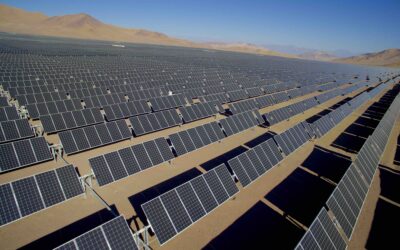
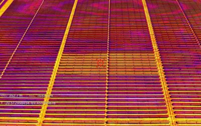
Simple Map’s aerial surveying platform is a testament to the company’s commitment to providing advanced solutions for the solar energy industry. The platform is engineered to leverage drone technology for conducting comprehensive aerial surveys of potential and existing solar project sites. These drones, equipped with cutting-edge sensors and high-resolution cameras, gather detailed data on topography, sunlight exposure, and environmental conditions—crucial information for the effective planning and implementation of solar energy systems.
The Open Source Advantage
What sets Simple Map’s platform apart is its open source framework. This approach allows for unparalleled flexibility and customization, enabling energy companies to tailor the software to their specific operational needs without the burden of licensing fees or the limitations of proprietary systems. The open source model encourages a collaborative environment where developers worldwide can contribute to the platform’s continuous improvement, ensuring it remains at the forefront of solar energy technology.
Implementation Strategy for Energy Companies
Adopting Simple Map’s solar aerial surveying platform within an energy company’s infrastructure involves several key steps:
1. Setup and Customization
The initial phase focuses on integrating the platform with the company’s existing IT environment, configuring it to run seamlessly on their subdomain. This involves customizing the platform’s interface, ensuring compatibility with existing databases, and adhering to strict data security protocols. Given the open source nature of the platform, companies have the freedom to adjust and modify the software to meet their precise requirements.
2. Drone Fleet Integration
The next step involves synchronizing the company’s drone fleet with the platform. This includes installing the necessary software on the drones to enable real-time data transmission and ensuring they are equipped with the appropriate sensors for accurate data collection. The platform’s capability to manage multiple drones simultaneously dramatically enhances the efficiency of surveying large or inaccessible areas.
3. Data Analysis and Reporting
At the core of Simple Map’s platform is its sophisticated data analysis engine. After data collection, the platform processes and analyzes the information to produce comprehensive reports on site suitability, estimated energy production, and environmental assessments. These insights are invaluable for energy companies, aiding in informed decision-making and strategic planning of solar projects.
4. Ongoing Development and Enhancement
The open source nature of the platform means it benefits from continuous enhancements and updates contributed by the global developer community. Energy companies can also play an active role in this process, developing new features and functionalities to meet evolving industry needs. This collaborative approach ensures the platform remains cutting-edge, driving innovation in solar energy surveying.
Conclusion
Simple Map’s open source solar aerial surveying platform represents a significant advancement in solar energy project planning and monitoring. By providing an adaptable, cost-effective, and efficient solution tailored specifically for the solar industry, the platform empowers energy companies to harness the full potential of solar energy. Through collaboration and innovation, Simple Map is setting new standards in the sector, contributing to the broader adoption of renewable energy and a more sustainable future.

0 Comments